


reco

BADEY
User
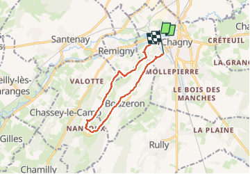

Length
10.6 km

Max alt
377 m

Uphill gradient
183 m
Km-Effort
13 km

Min alt
217 m

Downhill gradient
186 m
Boucle
No
Creation date :
2024-02-17 13:36:08.952
Updated on :
2024-03-11 12:29:39.409
2h23
Difficulty : Difficult

FREE GPS app for hiking
 SityTrail
IGN / Geographical institutes
SityTrail Plus
The world is yours!
About
Trail Walking of 10.6 km to be discovered at Bourgogne-Franche-Comté, Saône-et-Loire, Chagny. This trail is proposed by BADEY.
Positioning
Country:
France
Region :
Bourgogne-Franche-Comté
Department/Province :
Saône-et-Loire
Municipality :
Chagny
Location:
Unknown
Start:(Dec)
Start:(UTM)
632753 ; 5196579 (31T) N.
Comments