


bois des gonards

jumbo0861
User
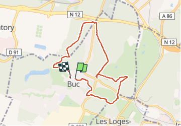

Length
7.8 km

Max alt
182 m

Uphill gradient
164 m
Km-Effort
10 km

Min alt
99 m

Downhill gradient
165 m
Boucle
Yes
Creation date :
2024-03-11 13:06:41.822
Updated on :
2024-03-11 15:17:03.596
2h10
Difficulty : Medium

FREE GPS app for hiking
 SityTrail
IGN / Geographical institutes
SityTrail Plus
The world is yours!
About
Trail Walking of 7.8 km to be discovered at Ile-de-France, Yvelines, Buc. This trail is proposed by jumbo0861.
Positioning
Country:
France
Region :
Ile-de-France
Department/Province :
Yvelines
Municipality :
Buc
Location:
Unknown
Start:(Dec)
Start:(UTM)
435824 ; 5402828 (31U) N.
Comments