


11.3.24.3 chapelles. vernegues.alain aep

NADINE52
User
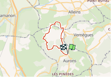

Length
10.9 km

Max alt
306 m

Uphill gradient
153 m
Km-Effort
13 km

Min alt
226 m

Downhill gradient
152 m
Boucle
Yes
Creation date :
2024-03-12 10:07:29.049
Updated on :
2024-03-12 14:15:04.219
2h52
Difficulty : Difficult

FREE GPS app for hiking
 SityTrail
IGN / Geographical institutes
SityTrail Plus
The world is yours!
About
Trail Walking of 10.9 km to be discovered at Provence-Alpes-Côte d'Azur, Bouches-du-Rhône, Aurons. This trail is proposed by NADINE52.
Positioning
Country:
France
Region :
Provence-Alpes-Côte d'Azur
Department/Province :
Bouches-du-Rhône
Municipality :
Aurons
Location:
Unknown
Start:(Dec)
Start:(UTM)
673731 ; 4837506 (31T) N.
Comments