


Rs Tarbes caminadour sud 2024

LouisROGER
User GUIDE
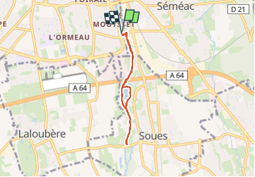

Length
5.4 km

Max alt
338 m

Uphill gradient
34 m
Km-Effort
5.8 km

Min alt
319 m

Downhill gradient
34 m
Boucle
Yes
Creation date :
2024-03-12 12:58:55.826
Updated on :
2024-03-12 15:27:36.825
2h28
Difficulty : Easy

FREE GPS app for hiking
 SityTrail
IGN / Geographical institutes
SityTrail Plus
The world is yours!
About
Trail Walking of 5.4 km to be discovered at Occitania, Hautespyrenees, Tarbes. This trail is proposed by LouisROGER.
Positioning
Country:
France
Region :
Occitania
Department/Province :
Hautespyrenees
Municipality :
Tarbes
Location:
Unknown
Start:(Dec)
Start:(UTM)
263794 ; 4789773 (31T) N.
Comments