


2024-03-12_17h44m35_visorando-si-pommiers-m-etait-conte

Mariolebeno
User
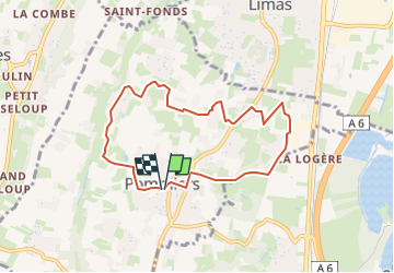

Length
7.5 km

Max alt
350 m

Uphill gradient
241 m
Km-Effort
10.7 km

Min alt
209 m

Downhill gradient
250 m
Boucle
Yes
Creation date :
2024-03-12 16:44:35.365
Updated on :
2024-03-19 06:07:03.51
1h30
Difficulty : Easy

FREE GPS app for hiking
 SityTrail
IGN / Geographical institutes
SityTrail Plus
The world is yours!
About
Trail Walking of 7.5 km to be discovered at Auvergne-Rhône-Alpes, Rhône, Pommiers. This trail is proposed by Mariolebeno.
Positioning
Country:
France
Region :
Auvergne-Rhône-Alpes
Department/Province :
Rhône
Municipality :
Pommiers
Location:
Unknown
Start:(Dec)
Start:(UTM)
631132 ; 5090420 (31T) N.
Comments