


MANDELIEU LA FORET DU GRAND DUC APRES RECONNAISSANCE

clintest
User
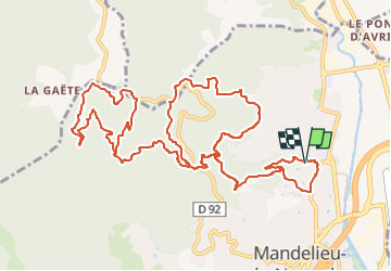

Length
16.9 km

Max alt
458 m

Uphill gradient
682 m
Km-Effort
26 km

Min alt
9 m

Downhill gradient
683 m
Boucle
Yes
Creation date :
2024-03-13 15:57:40.957
Updated on :
2024-03-13 15:58:29.198
5h54
Difficulty : Medium

FREE GPS app for hiking
 SityTrail
IGN / Geographical institutes
SityTrail Plus
The world is yours!
About
Trail On foot of 16.9 km to be discovered at Provence-Alpes-Côte d'Azur, Maritime Alps, Mandelieu-la-Napoule. This trail is proposed by clintest.
Positioning
Country:
France
Region :
Provence-Alpes-Côte d'Azur
Department/Province :
Maritime Alps
Municipality :
Mandelieu-la-Napoule
Location:
Unknown
Start:(Dec)
Start:(UTM)
333360 ; 4824579 (32T) N.
Comments