


2024-03-13_18h59m29_B14

LUTZMarc
User
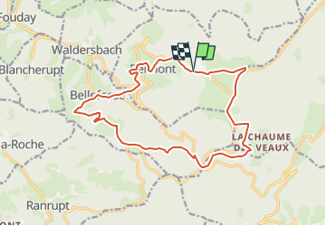

Length
16.4 km

Max alt
1103 m

Uphill gradient
552 m
Km-Effort
24 km

Min alt
636 m

Downhill gradient
545 m
Boucle
Yes
Creation date :
2024-03-13 17:59:29.991
Updated on :
2024-11-01 08:37:19.776
5h24
Difficulty : Medium

FREE GPS app for hiking
 SityTrail
IGN / Geographical institutes
SityTrail Plus
The world is yours!
About
Trail Walking of 16.4 km to be discovered at Grand Est, Bas-Rhin, Belmont. This trail is proposed by LUTZMarc.
Description
Assez raide ,beau paysage.
Positioning
Country:
France
Region :
Grand Est
Department/Province :
Bas-Rhin
Municipality :
Belmont
Location:
Unknown
Start:(Dec)
Start:(UTM)
370782 ; 5363083 (32U) N.
Comments