


Les Bories des Gauchers

supercolas
User GUIDE

Length
32 km

Max alt
421 m

Uphill gradient
734 m
Km-Effort
42 km

Min alt
184 m

Downhill gradient
736 m
Boucle
Yes
Creation date :
2024-03-14 12:23:25.602
Updated on :
2024-03-14 17:32:47.794
2h35
Difficulty : Medium

FREE GPS app for hiking
 SityTrail
IGN / Geographical institutes
SityTrail Plus
The world is yours!
About
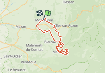
Trail Mountain bike of 32 km to be discovered at Provence-Alpes-Côte d'Azur, Vaucluse, Mormoiron. This trail is proposed by supercolas.
Description
Boucle Mormoiron, les Gauchers et Méthamis.
Eviter la remontée du Borie de Ste Ursume vers le DFCI (sentier non entretenu !!!!)
Positioning
Country:
France
Region :
Provence-Alpes-Côte d'Azur
Department/Province :
Vaucluse
Municipality :
Mormoiron
Location:
Unknown
Start:(Dec)
Start:(UTM)
674813 ; 4881690 (31T) N.
Comments