


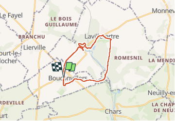
Boucle de Bouconvillers par Lavilletertre

Fky78
User


2h46
Difficulty : Difficult

FREE GPS app for hiking
 SityTrail
IGN / Geographical institutes
SityTrail Plus
The world is yours!
About
Trail Walking of 10.3 km to be discovered at Hauts-de-France, Oise, Bouconvillers. This trail is proposed by Fky78.
Description
Rando vallonnée , forêt , étangs, la Viosne ..... attention chemin qui passe près de la Source aux cochons à la sortie de Lavilletertre barré d arbres au moment de la rando prévoir escalade sinon continuer par la route
Photos


Positioning
Comments