Trail Walking Bouconvillers - Boucle de Bouconvillers par Lavilletertre - Photo

Boucle de Bouconvillers par Lavilletertre

 Fky78
Fky78

User

© OpenStreetMap contributors
Length
Length
10.3 km
Max alt
Max alt
126 m
Uphill gradient
Uphill gradient
139 m
Km-Effort
Km-Effort  
12.2 km
Min alt
Min alt
67 m
Downhill gradient
Downhill gradient
138 m
Boucle
Boucle
Yes
Creation date :
2024-03-14 12:25:27.632
Updated on :
2024-03-14 18:42:43.897

(0 Reviews)

Walking
Walking
2h46
Difficulty : Difficult

Scan this QR Code to open this trail in the SityTrail application

FREE GPS app for hiking

Logo SityTrail SityTrail

IGN / Geographical institutes

Download SityTrail from the App Store Download SityTrail from Google Play

Logo SityTrail SityTrail World

The world is yours!

Download SityTrail from the App Store Download SityTrail from Google Play Download SityTrail on Huawei AppGallery

About

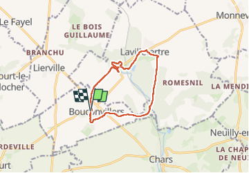
Trail Walking of 10.3 km to be discovered at Hauts-de-France, Oise, Bouconvillers. This trail is proposed by Fky78.

Description

Rando vallonnée , forêt , étangs, la Viosne ..... attention chemin qui passe près de la Source aux cochons à la sortie de Lavilletertre barré d arbres au moment de la rando prévoir escalade sinon continuer par la route

Elevation profile

Photos

Positioning

Country:
France
Region :
Hauts-de-France
Department/Province :
Oise
Municipality :
Bouconvillers
Location:
Unknown
Start:(UTM)
419981 ; 5447598 (31U) N.

Trails nearby

Trail Walking Moussy - Moussy - Photo
Walking
Fky78

Walking

Medium
(1)
Moussy, Ile-de-France, Val-d'Oise, France
8.8 km | 10.2 km-effort
2h 18min
Yes
Trail On foot Lavilletertre - Lavillertertre 12.6km - Photo
On foot
Djaie60

On foot

Medium
(1)
Lavilletertre, Hauts-de-France, Oise, France
12.7 km | 14.8 km-effort
Unknown
Yes
Trail Walking Nucourt - sources de l'Aubette - Photo
Walking
vdanion

Walking

Very easy
Nucourt, Ile-de-France, Val-d'Oise, France
11.2 km | 13.1 km-effort
2h 35min
Yes
Trail Walking Nucourt - Au coeur du Véxin, Nucourt le long de l'Aubette - Photo
Walking
tracegps

Walking

Medium
Nucourt, Ile-de-France, Val-d'Oise, France
22 km | 25 km-effort
4h 30min
Yes
Trail Walking Lavilletertre - la villetertre etang - Photo
Walking
Christine66

Walking

Medium
Lavilletertre, Hauts-de-France, Oise, France
9.9 km | 11.7 km-effort
2h 8min
Yes
Trail Walking Lavilletertre - Les étangs de Lavilletertre et Boucouvillers puis bois de Beaumont - Photo
Walking
Marie-Claire-mcp

Walking

Medium
(2)
Lavilletertre, Hauts-de-France, Oise, France
8.2 km | 9.5 km-effort
2h 10min
Yes
Trail Walking Lavilletertre - Lavilletertre, Bouconvilliers, Le Paradis, Bois de Beaumont 7.8 km - Photo
Walking
Marie-Claire-mcp

Walking

Medium
Lavilletertre, Hauts-de-France, Oise, France
7.8 km | 9.1 km-effort
2h 4min
Yes
Trail Walking Hadancourt-le-Haut-Clocher - mesnil lance levée  - Photo
Walking
Salers

Walking

Easy
Hadancourt-le-Haut-Clocher, Hauts-de-France, Oise, France
12.5 km | 15.3 km-effort
3h 35min
Yes
Trail Walking Chars - Chars - autour de la Viosne - Photo
Walking
marcel.F

Walking

Difficult
Chars, Ile-de-France, Val-d'Oise, France
12.5 km | 14.8 km-effort
2h 15min
Yes


Close
My subscriptions