


St Esteve

mhetpierre
User
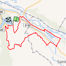

Length
12.3 km

Max alt
331 m

Uphill gradient
272 m
Km-Effort
15.9 km

Min alt
156 m

Downhill gradient
269 m
Boucle
Yes
Creation date :
2018-08-18 15:30:32.596
Updated on :
2018-08-18 15:30:32.596
4h44
Difficulty : Easy

FREE GPS app for hiking
 SityTrail
IGN / Geographical institutes
SityTrail Plus
The world is yours!
About
Trail Walking of 12.3 km to be discovered at Provence-Alpes-Côte d'Azur, Bouches-du-Rhône, Rognes. This trail is proposed by mhetpierre.
Positioning
Country:
France
Region :
Provence-Alpes-Côte d'Azur
Department/Province :
Bouches-du-Rhône
Municipality :
Rognes
Location:
Unknown
Start:(Dec)
Start:(UTM)
689955 ; 4841809 (31T) N.
Comments
