


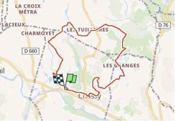
Chessy-les-Mnines (9,6 km - D. 145 m)

Thomasdanielle
User

Length
9.6 km

Max alt
317 m

Uphill gradient
145 m
Km-Effort
11.6 km

Min alt
222 m

Downhill gradient
145 m
Boucle
Yes
Creation date :
2024-03-14 13:07:34.0
Updated on :
2024-03-15 09:20:41.635
2h37
Difficulty : Medium

FREE GPS app for hiking
 SityTrail
IGN / Geographical institutes
SityTrail Plus
The world is yours!
About
Trail Walking of 9.6 km to be discovered at Auvergne-Rhône-Alpes, Rhône, Chessy. This trail is proposed by Thomasdanielle.
Description
D/A : parking route du Breuil
Positioning
Country:
France
Region :
Auvergne-Rhône-Alpes
Department/Province :
Rhône
Municipality :
Chessy
Location:
Unknown
Start:(Dec)
Start:(UTM)
625248 ; 5082957 (31T) N.
Comments