


CEYRESTE MP 04.24

michelpaulin
User
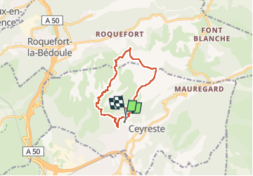

Length
11.5 km

Max alt
517 m

Uphill gradient
469 m
Km-Effort
17.7 km

Min alt
122 m

Downhill gradient
446 m
Boucle
No
Creation date :
2024-03-15 08:19:41.0
Updated on :
2024-03-15 12:03:52.114

FREE GPS app for hiking
 SityTrail
IGN / Geographical institutes
SityTrail Plus
The world is yours!
About
Trail of 11.5 km to be discovered at Provence-Alpes-Côte d'Azur, Bouches-du-Rhône, Ceyreste. This trail is proposed by michelpaulin.
Description
Jolis sentiers ombragés dans la première partie
Photos


Positioning
Country:
France
Region :
Provence-Alpes-Côte d'Azur
Department/Province :
Bouches-du-Rhône
Municipality :
Ceyreste
Location:
Unknown
Start:(Dec)
Start:(UTM)
713478 ; 4788662 (31T) N.
Comments