


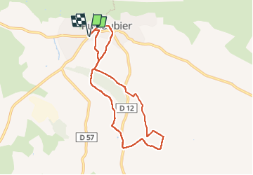
Puyloubier - chapelle st pancrace et st roch - glaciere

mhetpierre
User

Length
8.1 km

Max alt
361 m

Uphill gradient
135 m
Km-Effort
9.9 km

Min alt
265 m

Downhill gradient
134 m
Boucle
Yes
Creation date :
2024-03-15 09:39:21.0
Updated on :
2024-03-20 14:30:58.751
2h14
Difficulty : Medium

FREE GPS app for hiking
 SityTrail
IGN / Geographical institutes
SityTrail Plus
The world is yours!
About
Trail Walking of 8.1 km to be discovered at Provence-Alpes-Côte d'Azur, Bouches-du-Rhône, Puyloubier. This trail is proposed by mhetpierre.
Positioning
Country:
France
Region :
Provence-Alpes-Côte d'Azur
Department/Province :
Bouches-du-Rhône
Municipality :
Puyloubier
Location:
Unknown
Start:(Dec)
Start:(UTM)
715814 ; 4822463 (31T) N.
Comments