


Villespassans avec Coursan

crognon
User
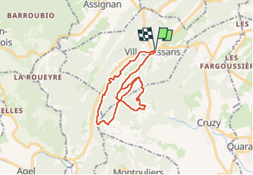

Length
16.4 km

Max alt
259 m

Uphill gradient
362 m
Km-Effort
21 km

Min alt
112 m

Downhill gradient
363 m
Boucle
Yes
Creation date :
2024-03-15 08:46:14.147
Updated on :
2024-03-15 15:18:52.687
6h32
Difficulty : Easy

FREE GPS app for hiking
 SityTrail
IGN / Geographical institutes
SityTrail Plus
The world is yours!
About
Trail Walking of 16.4 km to be discovered at Occitania, Hérault, Villespassans. This trail is proposed by crognon.
Positioning
Country:
France
Region :
Occitania
Department/Province :
Hérault
Municipality :
Villespassans
Location:
Unknown
Start:(Dec)
Start:(UTM)
493208 ; 4803171 (31T) N.
Comments