


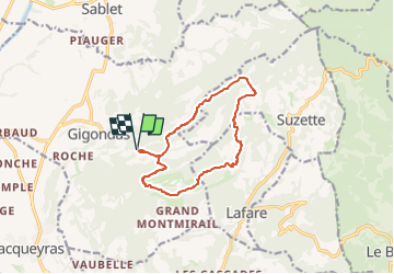
Tour des Dentelles depuis les Florets

supercolas
User GUIDE

Length
12.1 km

Max alt
584 m

Uphill gradient
634 m
Km-Effort
21 km

Min alt
255 m

Downhill gradient
634 m
Boucle
Yes
Creation date :
2024-03-15 19:20:13.908
Updated on :
2024-03-15 19:53:09.628
4h30
Difficulty : Difficult

FREE GPS app for hiking
 SityTrail
IGN / Geographical institutes
SityTrail Plus
The world is yours!
About
Trail Walking of 12.1 km to be discovered at Provence-Alpes-Côte d'Azur, Vaucluse, Gigondas. This trail is proposed by supercolas.
Description
Gigondas
Positioning
Country:
France
Region :
Provence-Alpes-Côte d'Azur
Department/Province :
Vaucluse
Municipality :
Gigondas
Location:
Unknown
Start:(Dec)
Start:(UTM)
661319 ; 4891685 (31T) N.
Comments