


Erome

meillon
User

Length
6.3 km

Max alt
374 m

Uphill gradient
283 m
Km-Effort
10.1 km

Min alt
140 m

Downhill gradient
282 m
Boucle
Yes
Creation date :
2024-03-16 09:54:08.227
Updated on :
2024-03-16 13:24:22.29
3h29
Difficulty : Medium

FREE GPS app for hiking
 SityTrail
IGN / Geographical institutes
SityTrail Plus
The world is yours!
About
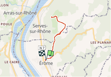
Trail Walking of 6.3 km to be discovered at Auvergne-Rhône-Alpes, Drôme, Érôme. This trail is proposed by meillon.
Description
Montée vers le belvédère du puy de Serves.
jolies vues sur le Rhône
Positioning
Country:
France
Region :
Auvergne-Rhône-Alpes
Department/Province :
Drôme
Municipality :
Érôme
Location:
Unknown
Start:(Dec)
Start:(UTM)
643262 ; 4997994 (31T) N.
Comments