


Sur le + beau de la trace de l'origine Trail de Bruniquel avec Marie 🌞👍

J-Mi
User
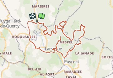

Length
30 km

Max alt
450 m

Uphill gradient
1268 m
Km-Effort
46 km

Min alt
119 m

Downhill gradient
1273 m
Boucle
Yes
Creation date :
2024-03-17 07:05:55.168
Updated on :
2024-03-17 07:15:55.191
0m
Difficulty : Difficult

FREE GPS app for hiking
 SityTrail
IGN / Geographical institutes
SityTrail Plus
The world is yours!
About
Trail Trail of 30 km to be discovered at Occitania, Tarn-et-Garonne, Bruniquel. This trail is proposed by J-Mi.
Description
30km 1300D
Positioning
Country:
France
Region :
Occitania
Department/Province :
Tarn-et-Garonne
Municipality :
Bruniquel
Location:
Unknown
Start:(Dec)
Start:(UTM)
393608 ; 4875394 (31T) N.
Comments