


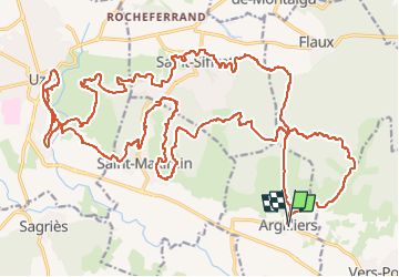
rando uzes mars 2024

mthomas30
User

Length
42 km

Max alt
210 m

Uphill gradient
775 m
Km-Effort
52 km

Min alt
65 m

Downhill gradient
775 m
Boucle
Yes
Creation date :
2024-03-17 07:01:44.729
Updated on :
2024-03-17 11:15:31.444
3h44
Difficulty : Medium

FREE GPS app for hiking
 SityTrail
IGN / Geographical institutes
SityTrail Plus
The world is yours!
About
Trail Mountain bike of 42 km to be discovered at Occitania, Gard, Argilliers. This trail is proposed by mthomas30.
Positioning
Country:
France
Region :
Occitania
Department/Province :
Gard
Municipality :
Argilliers
Location:
Unknown
Start:(Dec)
Start:(UTM)
619960 ; 4870648 (31T) N.
Comments