


St Vincent-rive d’Holt (Lot)

houbart
User
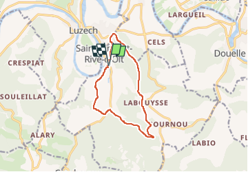

Length
11.6 km

Max alt
300 m

Uphill gradient
435 m
Km-Effort
17.4 km

Min alt
102 m

Downhill gradient
434 m
Boucle
Yes
Creation date :
2024-03-17 13:37:43.753
Updated on :
2024-03-24 08:21:25.567
3h57
Difficulty : Difficult

FREE GPS app for hiking
 SityTrail
IGN / Geographical institutes
SityTrail Plus
The world is yours!
About
Trail Walking of 11.6 km to be discovered at Occitania, Lot, Saint-Vincent-Rive-d'Olt. This trail is proposed by houbart.
Positioning
Country:
France
Region :
Occitania
Department/Province :
Lot
Municipality :
Saint-Vincent-Rive-d'Olt
Location:
Unknown
Start:(Dec)
Start:(UTM)
364771 ; 4924937 (31T) N.
Comments