


les caous 2

cb8310
User
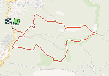

Length
6.3 km

Max alt
145 m

Uphill gradient
133 m
Km-Effort
8.1 km

Min alt
51 m

Downhill gradient
133 m
Boucle
Yes
Creation date :
2024-03-17 17:31:10.707
Updated on :
2025-04-03 09:12:34.903
1h49
Difficulty : Medium

FREE GPS app for hiking
 SityTrail
IGN / Geographical institutes
SityTrail Plus
The world is yours!
About
Trail Walking of 6.3 km to be discovered at Provence-Alpes-Côte d'Azur, Var, Saint-Raphaël. This trail is proposed by cb8310.
Positioning
Country:
France
Region :
Provence-Alpes-Côte d'Azur
Department/Province :
Var
Municipality :
Saint-Raphaël
Location:
Unknown
Start:(Dec)
Start:(UTM)
323014 ; 4812198 (32T) N.
Comments