


BALADE A BOISSEJOUR

walrou63
User
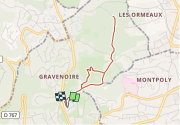

Length
3.5 km

Max alt
551 m

Uphill gradient
94 m
Km-Effort
4.8 km

Min alt
479 m

Downhill gradient
94 m
Boucle
Yes
Creation date :
2024-03-17 17:44:04.055
Updated on :
2024-03-17 17:44:05.657
1h05
Difficulty : Easy

FREE GPS app for hiking
 SityTrail
IGN / Geographical institutes
SityTrail Plus
The world is yours!
About
Trail Walking of 3.5 km to be discovered at Auvergne-Rhône-Alpes, Puy-de-Dôme, Ceyrat. This trail is proposed by walrou63.
Positioning
Country:
France
Region :
Auvergne-Rhône-Alpes
Department/Province :
Puy-de-Dôme
Municipality :
Ceyrat
Location:
Unknown
Start:(Dec)
Start:(UTM)
504913 ; 5066254 (31T) N.
Comments