


Mont Ste Odile mur païen court

Joseph Mertens
User
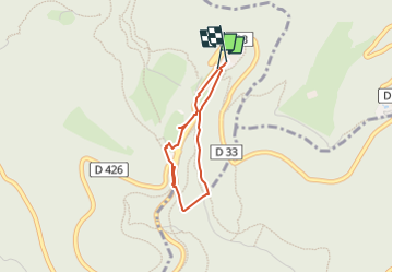

Length
2.2 km

Max alt
788 m

Uphill gradient
65 m
Km-Effort
3.1 km

Min alt
728 m

Downhill gradient
61 m
Boucle
Yes
Creation date :
2024-03-18 15:54:48.078
Updated on :
2024-03-18 15:59:27.07
42m
Difficulty : Easy

FREE GPS app for hiking
 SityTrail
IGN / Geographical institutes
SityTrail Plus
The world is yours!
About
Trail Walking of 2.2 km to be discovered at Grand Est, Bas-Rhin, Ottrott. This trail is proposed by Joseph Mertens.
Positioning
Country:
France
Region :
Grand Est
Department/Province :
Bas-Rhin
Municipality :
Ottrott
Location:
Unknown
Start:(Dec)
Start:(UTM)
381948 ; 5366125 (32U) N.
Comments