


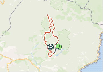
Étang de la Gabre du Gourin depuis Belle Barbe

GeorgesV.
User

Length
11.6 km

Max alt
227 m

Uphill gradient
269 m
Km-Effort
15.2 km

Min alt
29 m

Downhill gradient
269 m
Boucle
Yes
Creation date :
2024-03-18 16:10:49.0
Updated on :
2024-03-19 07:47:00.436

FREE GPS app for hiking
 SityTrail
IGN / Geographical institutes
SityTrail Plus
The world is yours!
About
Trail of 11.6 km to be discovered at Provence-Alpes-Côte d'Azur, Var, Saint-Raphaël. This trail is proposed by GeorgesV..
Description
Boucle : Col de Belle Barbe - Col du Mistral - Pont du Perthus - Lac aux Nénuphars - col du Perthus - Col du Baladou - Col de Belle Barbe
Positioning
Country:
France
Region :
Provence-Alpes-Côte d'Azur
Department/Province :
Var
Municipality :
Saint-Raphaël
Location:
Unknown
Start:(Dec)
Start:(UTM)
327575 ; 4813731 (32T) N.
Comments