


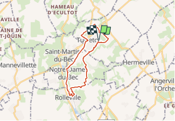
turretot db11km

doboul
User

Length
11 km

Max alt
108 m

Uphill gradient
130 m
Km-Effort
12.7 km

Min alt
37 m

Downhill gradient
130 m
Boucle
Yes
Creation date :
2024-03-18 16:58:25.647
Updated on :
2024-03-18 16:59:23.624
2h53
Difficulty : Easy
2h53
Difficulty : Difficult

FREE GPS app for hiking
 SityTrail
IGN / Geographical institutes
SityTrail Plus
The world is yours!
About
Trail On foot of 11 km to be discovered at Normandy, Seine-Maritime, Turretot. This trail is proposed by doboul.
Positioning
Country:
France
Region :
Normandy
Department/Province :
Seine-Maritime
Municipality :
Turretot
Location:
Unknown
Start:(Dec)
Start:(UTM)
300205 ; 5498727 (31U) N.
Comments