


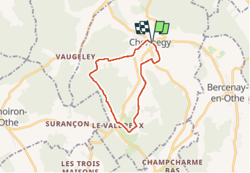
Randonnée à Chennegy

FPortier
User

Length
10.6 km

Max alt
247 m

Uphill gradient
136 m
Km-Effort
12.4 km

Min alt
152 m

Downhill gradient
137 m
Boucle
Yes
Creation date :
2024-03-19 07:59:35.895
Updated on :
2024-03-19 11:05:23.938
3h05
Difficulty : Difficult

FREE GPS app for hiking
 SityTrail
IGN / Geographical institutes
SityTrail Plus
The world is yours!
About
Trail Walking of 10.6 km to be discovered at Grand Est, Aube, Chennegy. This trail is proposed by FPortier.
Description
Balade chemins forêts
Photos


Positioning
Country:
France
Region :
Grand Est
Department/Province :
Aube
Municipality :
Chennegy
Location:
Unknown
Start:(Dec)
Start:(UTM)
563447 ; 5341670 (31U) N.
Comments