


Martel_Visite

jagarnier
User GUIDE
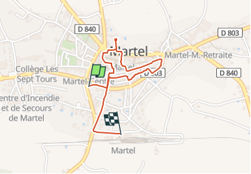

Length
1.6 km

Max alt
241 m

Uphill gradient
20 m
Km-Effort
1.8 km

Min alt
224 m

Downhill gradient
24 m
Boucle
No
Creation date :
2024-03-20 10:51:55.108
Updated on :
2024-05-02 05:01:31.613
24m
Difficulty : Easy

FREE GPS app for hiking
 SityTrail
IGN / Geographical institutes
SityTrail Plus
The world is yours!
About
Trail Walking of 1.6 km to be discovered at Occitania, Lot, Martel. This trail is proposed by jagarnier.
Photos

Positioning
Country:
France
Region :
Occitania
Department/Province :
Lot
Municipality :
Martel
Location:
Unknown
Start:(Dec)
Start:(UTM)
390101 ; 4976761 (31T) N.
Comments