


marignieu rg 2

robert gallet
User
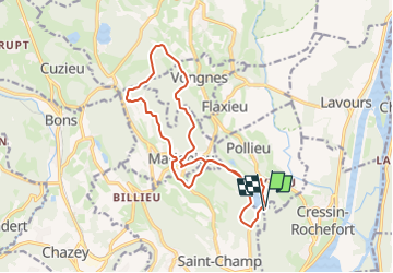

Length
15.9 km

Max alt
444 m

Uphill gradient
416 m
Km-Effort
21 km

Min alt
299 m

Downhill gradient
412 m
Boucle
Yes
Creation date :
2024-03-20 14:23:39.209
Updated on :
2024-03-20 14:24:16.291
4h52
Difficulty : Very difficult

FREE GPS app for hiking
 SityTrail
IGN / Geographical institutes
SityTrail Plus
The world is yours!
About
Trail Walking of 15.9 km to be discovered at Auvergne-Rhône-Alpes, Ain, Pollieu. This trail is proposed by robert gallet.
Positioning
Country:
France
Region :
Auvergne-Rhône-Alpes
Department/Province :
Ain
Municipality :
Pollieu
Location:
Unknown
Start:(Dec)
Start:(UTM)
713564 ; 5074025 (31T) N.
Comments