Trail Walking Chantonnay - GR364-Jour n° 5 - Photo
 dudu79
dudu79

User

© OpenStreetMap contributors
Length
Length
25 km
Max alt
Max alt
109 m
Uphill gradient
Uphill gradient
368 m
Km-Effort
Km-Effort  
30 km
Min alt
Min alt
29 m
Downhill gradient
Downhill gradient
338 m
Boucle
Boucle
No
Creation date :
2024-03-20 20:42:02.523
Updated on :
2024-04-17 08:19:54.366

(0 Reviews)

Walking
Walking
6h49
Difficulty : Very difficult

Scan this QR Code to open this trail in the SityTrail application

FREE GPS app for hiking

Logo SityTrail SityTrail

IGN / Geographical institutes

Download SityTrail from the App Store Download SityTrail from Google Play

Logo SityTrail SityTrail World

The world is yours!

Download SityTrail from the App Store Download SityTrail from Google Play Download SityTrail on Huawei AppGallery

About

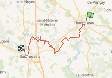
Trail Walking of 25 km to be discovered at Pays de la Loire, Vendée, Chantonnay. This trail is proposed by dudu79.

Description

Chantonnay à Bournezeau

Elevation profile

Positioning

Country:
France
Region :
Pays de la Loire
Department/Province :
Vendée
Municipality :
Chantonnay
Location:
Unknown
Start:(UTM)
649390 ; 5172393 (30T) N.

Trails nearby

Trail Other activity Chantonnay - Circuit du lac de l'Angle Guignard - Chantonnay - Photo
Other activity
philturp

Other activity

Very easy
Chantonnay, Pays de la Loire, Vendée, France
13.9 km | 17.6 km-effort
Unknown
Yes
Trail Mountain bike Sigournais - Circuit de Rochereau - Photo
Mountain bike
tracegps

Mountain bike

Medium
Sigournais, Pays de la Loire, Vendée, France
24 km | 27 km-effort
2h 15min
No
Trail Walking Chantonnay - Chantonnay la caillere st hilaire  - Photo
Walking
Salers

Walking

Medium
Chantonnay, Pays de la Loire, Vendée, France
20 km | 24 km-effort
6h 16min
No
Trail Road bike Chantonnay - Plaine de Chantonnay et Château d'eau de la Vendée - Photo
Road bike
brunodujura

Road bike

Medium
Chantonnay, Pays de la Loire, Vendée, France
59 km | 68 km-effort
3h 59min
Yes
Trail Walking Chantonnay - Sentier des Passerelles - Chantonnay - Photo
Walking
neoroll44

Walking

Difficult
Chantonnay, Pays de la Loire, Vendée, France
12.7 km | 15.2 km-effort
3h 18min
Yes
Trail Walking Chantonnay - Sentier de la Nouette - Chantonnay - Photo
Walking
neoroll44

Walking

Difficult
Chantonnay, Pays de la Loire, Vendée, France
12.5 km | 15.2 km-effort
3h 17min
Yes
Trail Walking Chantonnay - Circuit du lac de l'Angle Guignard - Chantonnay - Photo
Walking
neoroll44

Walking

Difficult
Chantonnay, Pays de la Loire, Vendée, France
13.9 km | 17.6 km-effort
3h 47min
Yes
Trail Walking Chantonnay - Sentier de Puybelliard par Ponsay - Chantonnay - Photo
Walking
neoroll44

Walking

Medium
Chantonnay, Pays de la Loire, Vendée, France
10.3 km | 11.7 km-effort
2h 35min
Yes
Trail Walking Sigournais - Sentier de Sainte Flayve - Sigournais - Photo
Walking
neoroll44

Walking

Difficult
Sigournais, Pays de la Loire, Vendée, France
14.7 km | 17 km-effort
3h 43min
Yes


Close
My subscriptions