


lariichette reco
© OpenStreetMap contributors


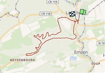
2h21
Difficulty : Medium


Length
9.4 km
Max alt
367 m
Uphill gradient
198 m
Km-Effort
12 km
Min alt
271 m
Downhill gradient
195 m
Boucle
Yes
Creation date :
2024-03-21 08:31:40.61
Updated on :
2024-03-21 11:22:29.761
2h21
Difficulty : Medium
FREE GPS app for hiking
 SityTrail
IGN / Geographical institutes
SityTrail Plus
The world is yours!
About
Trail Walking of 9.4 km to be discovered at Unknown, Canton Mersch, Larochette. This trail is proposed by houetphilippe@gmail.com.
Description
balade
Positioning
Country:
Luxembourg
Region :
Unknown
Department/Province :
Canton Mersch
Municipality :
Larochette
Location:
Unknown
Start:(Dec)
Start:(UTM)
299924 ; 5518401 (32U) N.
Comments