Trail Cross-country skiing Inari - 20240321 - Photo
 Frings
Frings

User

© OpenStreetMap contributors
Length
Length
10.9 km
Max alt
Max alt
539 m
Uphill gradient
Uphill gradient
260 m
Km-Effort
Km-Effort  
14.3 km
Min alt
Min alt
337 m
Downhill gradient
Downhill gradient
260 m
Boucle
Boucle
Yes
Creation date :
2024-03-21 07:44:44.94
Updated on :
2024-03-21 12:12:31.982

(0 Reviews)

Cross-country skiing
2h40
Difficulty : Very easy

Scan this QR Code to open this trail in the SityTrail application

FREE GPS app for hiking

Logo SityTrail SityTrail

IGN / Geographical institutes

Download SityTrail from the App Store Download SityTrail from Google Play

Logo SityTrail SityTrail World

The world is yours!

Download SityTrail from the App Store Download SityTrail from Google Play Download SityTrail on Huawei AppGallery

About

Trail Cross-country skiing of 10.9 km to be discovered at Unknown, Lapland, Inari. This trail is proposed by Frings.

Elevation profile

Positioning

Country:
Finland
Region :
Unknown
Department/Province :
Lapland
Municipality :
Inari
Location:
Unknown
Start:(UTM)
518983 ; 7581494 (35W) N.

Trails nearby

Trail On foot Inari - Poro, luontopolku - Photo
On foot
PRO

On foot

Easy
Inari, Unknown, Lapland, Finland
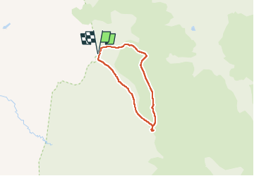
3.5 km | 3.9 km-effort
53min
Yes
Trail On foot Inari - Kiiruna, luontopolku - Photo
On foot
PRO

On foot

Easy
Inari, Unknown, Lapland, Finland
6.5 km | 8.2 km-effort
1h 52min
Yes


Close
My subscriptions