


Montgeard raccourci

pidjam
User
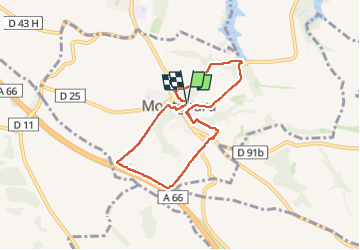

Length
7 km

Max alt
293 m

Uphill gradient
165 m
Km-Effort
9.2 km

Min alt
205 m

Downhill gradient
167 m
Boucle
Yes
Creation date :
2024-03-21 13:33:33.318
Updated on :
2024-03-21 15:36:08.837
1h45
Difficulty : Easy

FREE GPS app for hiking
 SityTrail
IGN / Geographical institutes
SityTrail Plus
The world is yours!
About
Trail Walking of 7 km to be discovered at Occitania, Haute-Garonne, Montgeard. This trail is proposed by pidjam.
Positioning
Country:
France
Region :
Occitania
Department/Province :
Haute-Garonne
Municipality :
Montgeard
Location:
Unknown
Start:(Dec)
Start:(UTM)
389323 ; 4799401 (31T) N.
Comments