


L’Escarene

Renefrt
User
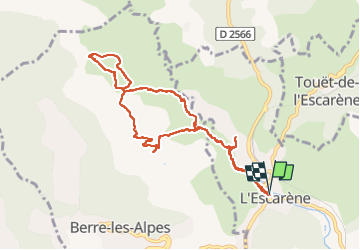

Length
10.1 km

Max alt
541 m

Uphill gradient
283 m
Km-Effort
13.9 km

Min alt
349 m

Downhill gradient
281 m
Boucle
Yes
Creation date :
2024-03-21 07:19:02.0
Updated on :
2024-03-21 16:01:06.509
4h39
Difficulty : Easy

FREE GPS app for hiking
 SityTrail
IGN / Geographical institutes
SityTrail Plus
The world is yours!
About
Trail Walking of 10.1 km to be discovered at Provence-Alpes-Côte d'Azur, Maritime Alps, L'Escarène. This trail is proposed by Renefrt.
Description
Très peu de balisage, surtout attention au premier changement de direction à gauche bien prendre la route bétonnée qui monte
Photos


Positioning
Country:
France
Region :
Provence-Alpes-Côte d'Azur
Department/Province :
Maritime Alps
Municipality :
L'Escarène
Location:
Unknown
Start:(Dec)
Start:(UTM)
367723 ; 4854836 (32T) N.
Comments