


Bourg et Comin après-midi du 21-03-2024

VANDERPUTTENMi
User GUIDE
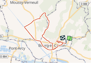

Length
8.1 km

Max alt
146 m

Uphill gradient
127 m
Km-Effort
9.8 km

Min alt
47 m

Downhill gradient
128 m
Boucle
Yes
Creation date :
2024-03-21 13:00:28.803
Updated on :
2024-03-21 18:43:23.138
2h13
Difficulty : Medium

FREE GPS app for hiking
 SityTrail
IGN / Geographical institutes
SityTrail Plus
The world is yours!
About
Trail Walking of 8.1 km to be discovered at Hauts-de-France, Aisne, Bourg-et-Comin. This trail is proposed by VANDERPUTTENMi.
Photos

Positioning
Country:
France
Region :
Hauts-de-France
Department/Province :
Aisne
Municipality :
Bourg-et-Comin
Location:
Unknown
Start:(Dec)
Start:(UTM)
548155 ; 5471792 (31U) N.
Comments