


Abbaye st Maurice Quimperlé

taguette
User
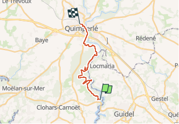

Length
16.6 km

Max alt
67 m

Uphill gradient
301 m
Km-Effort
21 km

Min alt
4 m

Downhill gradient
313 m
Boucle
No
Creation date :
2024-03-22 07:14:06.537
Updated on :
2024-03-22 11:32:36.314
4h17
Difficulty : Very difficult

FREE GPS app for hiking
 SityTrail
IGN / Geographical institutes
SityTrail Plus
The world is yours!
About
Trail Walking of 16.6 km to be discovered at Brittany, Finistère, Clohars-Carnoët. This trail is proposed by taguette.
Positioning
Country:
France
Region :
Brittany
Department/Province :
Finistère
Municipality :
Clohars-Carnoët
Location:
Unknown
Start:(Dec)
Start:(UTM)
460735 ; 5294501 (30T) N.
Comments