


Ladenne et Courcoussat.

MCARY
User
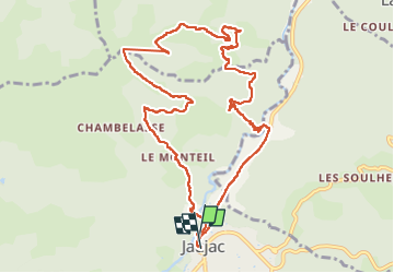

Length
11.9 km

Max alt
824 m

Uphill gradient
563 m
Km-Effort
19.4 km

Min alt
368 m

Downhill gradient
557 m
Boucle
Yes
Creation date :
2024-03-22 10:03:32.513
Updated on :
2024-03-22 16:18:02.984
4h32
Difficulty : Very difficult

FREE GPS app for hiking
 SityTrail
IGN / Geographical institutes
SityTrail Plus
The world is yours!
About
Trail Walking of 11.9 km to be discovered at Auvergne-Rhône-Alpes, Ardèche, Jaujac. This trail is proposed by MCARY.
Positioning
Country:
France
Region :
Auvergne-Rhône-Alpes
Department/Province :
Ardèche
Municipality :
Jaujac
Location:
Unknown
Start:(Dec)
Start:(UTM)
599524 ; 4943388 (31T) N.
Comments