MONTAGNE DE CLARE APRES RECONNAISSANCE trajet possible

clintest
User
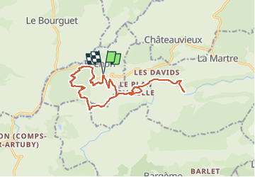

Length
16.1 km

Max alt
1256 m

Uphill gradient
644 m
Km-Effort
25 km

Min alt
871 m

Downhill gradient
641 m
Boucle
Yes
Creation date :
2024-03-23 14:52:03.35
Updated on :
2024-03-23 14:52:48.655
5h36
Difficulty : Medium

FREE GPS app for hiking
 SityTrail
IGN / Geographical institutes
SityTrail Plus
The world is yours!
About
Trail On foot of 16.1 km to be discovered at Provence-Alpes-Côte d'Azur, Var, Brenon. This trail is proposed by clintest.
Description
jusque pont notre dame
Positioning
Country:
France
Region :
Provence-Alpes-Côte d'Azur
Department/Province :
Var
Municipality :
Brenon
Location:
Unknown
Start:(Dec)
Start:(UTM)
302313 ; 4848817 (32T) N.
Comments