


Pic d'Alian

chasle
User
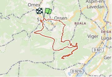

Length
10.6 km

Max alt
1081 m

Uphill gradient
672 m
Km-Effort
19.5 km

Min alt
505 m

Downhill gradient
674 m
Boucle
Yes
Creation date :
2024-03-24 08:22:07.837
Updated on :
2024-03-24 17:57:01.004
4h26
Difficulty : Difficult

FREE GPS app for hiking
 SityTrail
IGN / Geographical institutes
SityTrail Plus
The world is yours!
About
Trail Walking of 10.6 km to be discovered at Occitania, Hautespyrenees, Ségus. This trail is proposed by chasle.
Positioning
Country:
France
Region :
Occitania
Department/Province :
Hautespyrenees
Municipality :
Ségus
Location:
Unknown
Start:(Dec)
Start:(UTM)
738091 ; 4772763 (30T) N.
Comments