


M'ont Guerin

pje
User
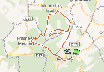

Length
10.2 km

Max alt
319 m

Uphill gradient
206 m
Km-Effort
13 km

Min alt
206 m

Downhill gradient
208 m
Boucle
Yes
Creation date :
2024-03-25 07:53:20.44
Updated on :
2024-03-25 10:38:17.065
2h44
Difficulty : Easy

FREE GPS app for hiking
 SityTrail
IGN / Geographical institutes
SityTrail Plus
The world is yours!
About
Trail Walking of 10.2 km to be discovered at Bourgogne-Franche-Comté, Jura, Moissey. This trail is proposed by pje.
Positioning
Country:
France
Region :
Bourgogne-Franche-Comté
Department/Province :
Jura
Municipality :
Moissey
Location:
Unknown
Start:(Dec)
Start:(UTM)
691563 ; 5230194 (31T) N.
Comments