


ouroux sur saone

mcterret
User
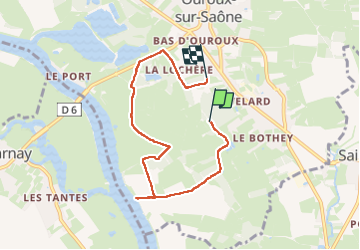

Length
6.1 km

Max alt
181 m

Uphill gradient
28 m
Km-Effort
6.5 km

Min alt
169 m

Downhill gradient
25 m
Boucle
No
Creation date :
2024-03-25 15:20:09.33
Updated on :
2024-03-25 16:48:53.757
1h22
Difficulty : Very easy

FREE GPS app for hiking
 SityTrail
IGN / Geographical institutes
SityTrail Plus
The world is yours!
About
Trail Walking of 6.1 km to be discovered at Bourgogne-Franche-Comté, Saône-et-Loire, Ouroux-sur-Saône. This trail is proposed by mcterret.
Positioning
Country:
France
Region :
Bourgogne-Franche-Comté
Department/Province :
Saône-et-Loire
Municipality :
Ouroux-sur-Saône
Location:
Unknown
Start:(Dec)
Start:(UTM)
649355 ; 5174577 (31T) N.
Comments