


Plaine des maraîchers de l'Ovalie en circuit

Emelle
User
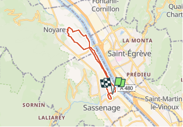

Length
11.1 km

Max alt
213 m

Uphill gradient
88 m
Km-Effort
12.3 km

Min alt
193 m

Downhill gradient
88 m
Boucle
Yes
Creation date :
2024-03-26 07:32:35.252
Updated on :
2024-03-26 10:35:40.788
2h18
Difficulty : Easy

FREE GPS app for hiking
 SityTrail
IGN / Geographical institutes
SityTrail Plus
The world is yours!
About
Trail Nordic walking of 11.1 km to be discovered at Auvergne-Rhône-Alpes, Isère, Sassenage. This trail is proposed by Emelle.
Positioning
Country:
France
Region :
Auvergne-Rhône-Alpes
Department/Province :
Isère
Municipality :
Sassenage
Location:
Unknown
Start:(Dec)
Start:(UTM)
709693 ; 5010115 (31T) N.
Comments