


rando Dabo st quirin

Christian Hirsch
User
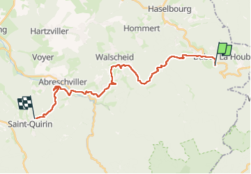

Length
24 km

Max alt
568 m

Uphill gradient
649 m
Km-Effort
33 km

Min alt
292 m

Downhill gradient
899 m
Boucle
No
Creation date :
2024-03-26 08:20:53.568
Updated on :
2024-03-26 16:48:32.255
6h20
Difficulty : Very difficult

FREE GPS app for hiking
 SityTrail
IGN / Geographical institutes
SityTrail Plus
The world is yours!
About
Trail Walking of 24 km to be discovered at Grand Est, Moselle, Dabo. This trail is proposed by Christian Hirsch.
Description
marche
Positioning
Country:
France
Region :
Grand Est
Department/Province :
Moselle
Municipality :
Dabo
Location:
Unknown
Start:(Dec)
Start:(UTM)
370978 ; 5389823 (32U) N.
Comments