


oui

evelyne10
User
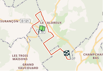

Length
5.4 km

Max alt
259 m

Uphill gradient
61 m
Km-Effort
6.3 km

Min alt
228 m

Downhill gradient
76 m
Boucle
No
Creation date :
2024-03-27 13:12:41.922
Updated on :
2024-03-27 15:17:00.633
2h01
Difficulty : Medium

FREE GPS app for hiking
 SityTrail
IGN / Geographical institutes
SityTrail Plus
The world is yours!
About
Trail Walking of 5.4 km to be discovered at Grand Est, Aube, Chennegy. This trail is proposed by evelyne10.
Description
ou
Positioning
Country:
France
Region :
Grand Est
Department/Province :
Aube
Municipality :
Chennegy
Location:
Unknown
Start:(Dec)
Start:(UTM)
561633 ; 5338086 (31U) N.
Comments