


Etoile Cussy

zachval
User

Length
31 km

Max alt
700 m

Uphill gradient
978 m
Km-Effort
44 km

Min alt
324 m

Downhill gradient
960 m
Boucle
Yes
Creation date :
2024-03-27 20:33:12.396
Updated on :
2024-03-27 20:34:10.153
0m
Difficulty : Very easy

FREE GPS app for hiking
 SityTrail
IGN / Geographical institutes
SityTrail Plus
The world is yours!
About
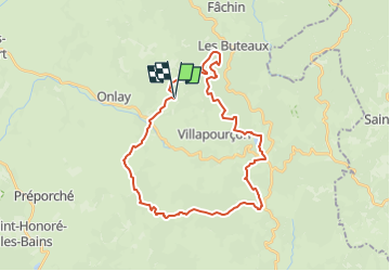
Trail Equestrian of 31 km to be discovered at Bourgogne-Franche-Comté, Nièvre, Villapourçon. This trail is proposed by zachval.
Positioning
Country:
France
Region :
Bourgogne-Franche-Comté
Department/Province :
Nièvre
Municipality :
Villapourçon
Location:
Unknown
Start:(Dec)
Start:(UTM)
571155 ; 5201634 (31T) N.
Comments