


moret

olivieraron
User
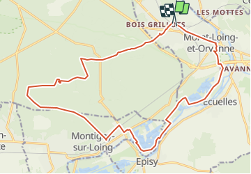

Length
21 km

Max alt
138 m

Uphill gradient
292 m
Km-Effort
25 km

Min alt
45 m

Downhill gradient
296 m
Boucle
No
Creation date :
2019-01-14 09:45:57.637
Updated on :
2021-10-25 09:25:17.47
15m
Difficulty : Unknown

FREE GPS app for hiking
 SityTrail
IGN / Geographical institutes
SityTrail Plus
The world is yours!
About
Trail Other activity of 21 km to be discovered at Ile-de-France, Seine-et-Marne, Moret-Loing-et-Orvanne. This trail is proposed by olivieraron.
Positioning
Country:
France
Region :
Ile-de-France
Department/Province :
Seine-et-Marne
Municipality :
Moret-Loing-et-Orvanne
Location:
Veneux-les-Sablons
Start:(Dec)
Start:(UTM)
484980 ; 5358494 (31U) N.
Comments