


Cascade de l'Aille (AV)

HENRY83
User
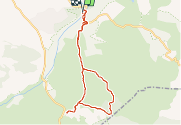

Length
9.4 km

Max alt
104 m

Uphill gradient
92 m
Km-Effort
10.6 km

Min alt
42 m

Downhill gradient
90 m
Boucle
Yes
Creation date :
2024-03-27 13:06:35.298
Updated on :
2024-04-01 06:37:25.494
2h24
Difficulty : Easy

FREE GPS app for hiking
 SityTrail
IGN / Geographical institutes
SityTrail Plus
The world is yours!
About
Trail Walking of 9.4 km to be discovered at Provence-Alpes-Côte d'Azur, Var, Vidauban. This trail is proposed by HENRY83.
Positioning
Country:
France
Region :
Provence-Alpes-Côte d'Azur
Department/Province :
Var
Municipality :
Vidauban
Location:
Unknown
Start:(Dec)
Start:(UTM)
293883 ; 4808045 (32T) N.
Comments