


Bourbouloux

Michelraimbault
User
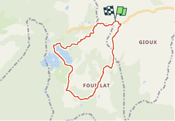

Length
7.5 km

Max alt
905 m

Uphill gradient
137 m
Km-Effort
9.4 km

Min alt
829 m

Downhill gradient
138 m
Boucle
Yes
Creation date :
2024-03-28 13:04:33.002
Updated on :
2024-03-28 15:31:12.162
2h14
Difficulty : Easy

FREE GPS app for hiking
 SityTrail
IGN / Geographical institutes
SityTrail Plus
The world is yours!
About
Trail Walking of 7.5 km to be discovered at Auvergne-Rhône-Alpes, Puy-de-Dôme, Bagnols. This trail is proposed by Michelraimbault.
Positioning
Country:
France
Region :
Auvergne-Rhône-Alpes
Department/Province :
Puy-de-Dôme
Municipality :
Bagnols
Location:
Unknown
Start:(Dec)
Start:(UTM)
472448 ; 5035145 (31T) N.
Comments