


La voie royale et les monument de 1871

dcharbonnier
User
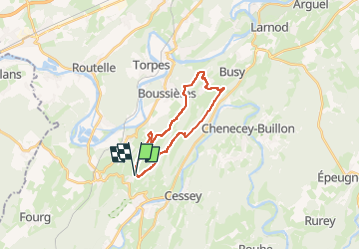

Length
18.4 km

Max alt
489 m

Uphill gradient
503 m
Km-Effort
25 km

Min alt
248 m

Downhill gradient
502 m
Boucle
Yes
Creation date :
2024-03-28 17:25:09.0
Updated on :
2024-03-28 17:25:10.888
5h42
Difficulty : Difficult

FREE GPS app for hiking
 SityTrail
IGN / Geographical institutes
SityTrail Plus
The world is yours!
About
Trail Walking of 18.4 km to be discovered at Bourgogne-Franche-Comté, Doubs, Abbans-Dessus. This trail is proposed by dcharbonnier.
Positioning
Country:
France
Region :
Bourgogne-Franche-Comté
Department/Province :
Doubs
Municipality :
Abbans-Dessus
Location:
Unknown
Start:(Dec)
Start:(UTM)
718564 ; 5222294 (31T) N.
Comments