


LES 12 DERNIERS AU RCY

Gbreuilh
User
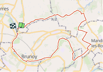

Length
12.3 km

Max alt
91 m

Uphill gradient
112 m
Km-Effort
13.8 km

Min alt
36 m

Downhill gradient
111 m
Boucle
Yes
Creation date :
2024-03-28 18:19:55.568
Updated on :
2024-03-28 18:21:35.974
3h08
Difficulty : Difficult

FREE GPS app for hiking
 SityTrail
IGN / Geographical institutes
SityTrail Plus
The world is yours!
About
Trail Walking of 12.3 km to be discovered at Ile-de-France, Essonne, Yerres. This trail is proposed by Gbreuilh.
Description
Petite boucle sympathique de 12 kms sans difficulté.
Positioning
Country:
France
Region :
Ile-de-France
Department/Province :
Essonne
Municipality :
Yerres
Location:
Unknown
Start:(Dec)
Start:(UTM)
463026 ; 5395077 (31U) N.
Comments