


SityTrail - floirac

Gpoujade
User
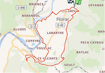

Length
12.4 km

Max alt
255 m

Uphill gradient
286 m
Km-Effort
16.2 km

Min alt
106 m

Downhill gradient
301 m
Boucle
Yes
Creation date :
2024-03-29 13:23:26.145
Updated on :
2024-03-29 13:31:27.207
3h41
Difficulty : Difficult

FREE GPS app for hiking
 SityTrail
IGN / Geographical institutes
SityTrail Plus
The world is yours!
About
Trail Walking of 12.4 km to be discovered at Occitania, Lot, Floirac. This trail is proposed by Gpoujade.
Description
Boucle au départ de Floirac vers le cirque de Montvalent et retour
Positioning
Country:
France
Region :
Occitania
Department/Province :
Lot
Municipality :
Floirac
Location:
Unknown
Start:(Dec)
Start:(UTM)
394332 ; 4974905 (31T) N.
Comments